Up to 2 TB USB Memory Drive |

Up to 200 m AGL - Above Ground Level |

USB Camera Interface |

WiFi & GSM Embedded WiFi, Cellular Modem |

PPK/RTK Dual/Single GPS-Aided INS |

3-5 cm Point Cloud Accuracy |

0.37 kg Weight w/o LiDAR |

4 Watts Power Draw w/o LiDAR |
The RESEPI GEN-II system is the latest product addition to the RESEPI family. It is the result of years of market research and disciplined practice of the fundamentals of engineering. This surveyor’s dream is built for an unrivaled ability to be versatile in nature; serving and delivering the best in class data for various use cases spanning aerial, mobile, and pedestrian based applications. Feature rich and intuitive workflows allow for confident and successful operation regardless of the size of the project at hand.
LiDAR
RESEPI GEN-II with XT-32M2X LiDAR uses the enhanced version of the mobile XT-32 LiDAR scanner, which features a lighter weight and an extended detection range compared to its predecessor model. It enables an M2X-equipped RESEPI to fly longer, combined with a higher recommended maximum AGL and wider vertical FOV, to map larger areas and sites with dense vegetation cover more effectively. It is an all-around desirable system, offering the benefits of best-in-class data accuracy, better detection range, high point density, and versatility.

Overview
The RESEPI (Remote Sensing Payload Instrument) GEN-II payload is an advanced, next-generation, sensor-fusion platform designed for accuracy-focused real-time and post-processed aerial, mobile, and pedestrian-based remote sensing applications. RESEPI GEN-II utilizes the Inertial Labs’ Dual Antenna Inertial Navigation System (INS-D), a high-performance and expandable navigation system powered by Inertial Labs’ Extended Kalman Filter (EKF). Within this system lies a Tactical Grade Inertial Measurement Unit (IMU), the Kernel-210, also by Inertial Labs. It provides more expandability over its predecessor by offering end-users and integrators the ability to integrate their platforms by taking advantage of built-in software integrations made by MAVLink and DJI’s Payload SDK (PSDK). Benefit from two new camera options with a wider field of view, faster shutter speeds, and higher resolution images. Field-swappable mounts and accessories easily integrate with platforms like the WISPR Ranger Pro 1100, Freefly Astro, Sony Airpeak S1, and DJI M350. The RESEPI GEN-II platform features a more powerful on-board computing module for real-time point cloud visualization and further integrations with external/additional sensing modules, giving users the ability to integrate and synchronize their additional cameras and LiDAR or input-aiding data to the navigation filter from wheel speed sensors, encoders, external IMU’s or Air Data Computers (ADC). This payload is ideally suited for plug-and-play with end-users and engineering firms looking to adopt a hardware package that offers customization and expandability with a versatile remote sensing solution.
Applications
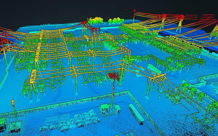
The RESEPI GEN-II XT-32M2X was strategically designed for multiple application bases with mounting options for mobile vehicles, DJI supported drones (DJI M300, M350, M600 Pro), custom drones, handheld platforms (including the RESEPI LiDAR Payload Backpack), indoor robotics vehicles, the Freefly Alta-X and Astro, WISPR Ranger Pro 1100, Sony Airpeak S1, and many more. Because of this diverse mounting portfolio, the RESEPI can be used for many services including utilities mapping (power lines), construction volumetrics, site surveying, precision agriculture, forestry, mining operations, and more.

.png?width=75&height=47&name=RESEPI-GEN-II-M2X-R2-red01%20(1).png)